


By Shashikant Nishant Sharma
The Homer Hoyt Sector Model, also known as the Hoyt Model or the Sectoral Model, is a theory of urban land use that was developed by economist Homer Hoyt in 1939. This model was an alternative to the earlier Burgess Concentric Zone Model and offered a different perspective on how cities grow and how different social groups and land uses are distributed within an urban area.
Overview of the Model
The Sector Model suggests that cities develop in wedge-shaped sectors rather than concentric rings. According to Hoyt, the city grows outward from the center, but land use is not evenly distributed in all directions. Instead, certain areas or “sectors” of a city become dominated by particular types of land use due to historical, environmental, or economic factors.
Key Features of the Sector Model
- Sector Formation:
- Growth Along Transportation Routes: Hoyt observed that cities tend to grow along transportation routes, such as roads, railways, or rivers. These routes create corridors or sectors of development that extend outward from the city center.
- Direction of Growth: The direction in which sectors develop is often influenced by natural features (such as rivers or hills), transportation infrastructure, and historical patterns of land use. For example, industrial sectors may develop along railways or rivers, while residential areas may spread along major roads.
- Land Use Sectors:
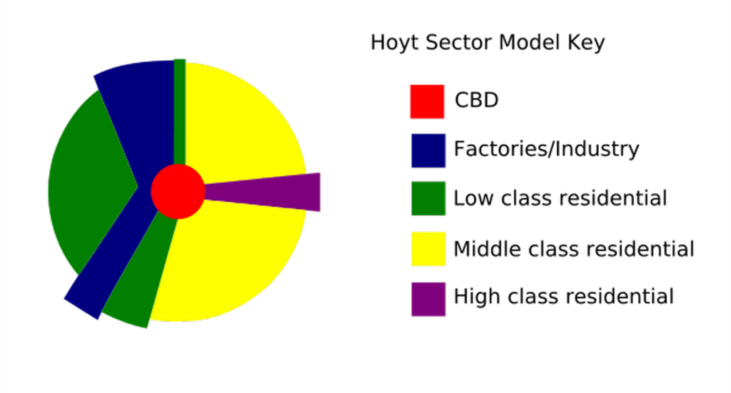
- Central Business District (CBD): At the heart of the model is the CBD, similar to the Burgess model. This area is the commercial and business hub of the city, characterized by high land values and dense development.
- High-Rent Residential Sector: High-income residential areas tend to develop in sectors radiating out from the CBD, often along desirable corridors such as scenic routes, waterfronts, or major roads. These areas are typically situated away from industrial zones and are characterized by larger homes, better amenities, and more green spaces.
- Middle-Rent Residential Sector: Middle-income housing tends to develop in sectors adjacent to the high-rent areas but further from the CBD. These areas offer moderate amenities and are more affordable than high-rent sectors.
- Low-Rent Residential Sector: Low-income housing tends to develop near industrial zones and transportation routes, where land is cheaper and less desirable for higher-income residents. These areas may suffer from pollution, noise, and other negative externalities associated with industrial activities.
- Industrial Sector: Industrial land use often forms a sector extending out from the CBD, typically along major transportation routes like railways or rivers. This area may include factories, warehouses, and other industrial facilities that require access to transportation and lower land costs.
- Retail and Commercial Sector: Retail and commercial land use also tends to follow major transportation routes, forming sectors that extend outward from the CBD. These areas may include shopping districts, markets, and other commercial activities that benefit from high accessibility.
- Influence of Historical and Social Factors:
- Hoyt emphasized that historical and social factors play a significant role in determining the location and growth of different sectors. For example, the presence of a prestigious neighborhood or an undesirable industrial zone can influence the development of surrounding areas.
- Sector Stability and Change:
- Stability: Once a sector is established, it tends to remain stable over time. High-income residential areas, for example, may remain prestigious for decades due to the quality of housing, social status, and amenities.
- Change: However, sectors can also change over time due to economic shifts, changes in transportation technology, or urban redevelopment. For example, a decline in industrial activity may lead to the conversion of industrial sectors into residential or commercial areas.
Advantages of the Sector Model

- Reflects Real-World Urban Patterns: The Sector Model was based on empirical observations of American cities, particularly Chicago. It reflects the tendency of cities to develop along transportation routes and the uneven distribution of land uses.
- Flexible and Dynamic: The model accounts for the influence of transportation infrastructure and historical factors, making it more adaptable to different urban contexts compared to the rigid concentric rings of the Burgess Model.
- Explains Social Segregation: The model helps explain social segregation within cities, showing how different income groups and land uses can become concentrated in specific sectors based on historical, economic, and environmental factors.
Criticisms and Limitations
- Oversimplification: Like all models, the Sector Model is a simplification of reality. It assumes that land use within a sector is homogeneous and that all cities develop in a similar manner, which may not always be the case.
- Inapplicability to Modern Cities: The model was developed based on observations of early 20th-century American cities. Modern cities, especially those with complex, polycentric structures, do not always conform to the sectoral pattern.
- Neglects Other Factors: The Sector Model does not fully account for the impact of government policies, zoning laws, or changes in transportation technology that can influence urban development. For example, the development of highways or public transit systems can drastically alter urban growth patterns, leading to more dispersed or decentralized urban forms.
- Static Nature: While the model recognizes that sectors can change over time, it does not fully capture the dynamic and evolving nature of urban development, particularly in rapidly growing cities.
Relevance Today
Despite its limitations, the Hoyt Sector Model remains a valuable tool for understanding certain aspects of urban growth and land use. It is particularly useful for analyzing cities where transportation routes have played a significant role in shaping development patterns. The model has also influenced subsequent theories in urban planning, including the Multiple Nuclei Model, which builds on the idea of differentiated urban zones but allows for a more complex and multi-centered urban structure.
In contemporary urban planning, the Sector Model serves as a historical reference point and a foundation for more nuanced models that take into account the complexities of modern urban life. It helps urban planners and geographers understand the spatial distribution of social groups and land uses and provides insights into the processes that shape the evolution of urban areas over time.
References
Adams, J. S. (2005). Hoyt, H. 1939: The structure and growth of residential neighborhoods in American cities. Washington, DC: Federal Housing Administration. Progress in Human Geography, 29(3), 321-325.
Beauregard, R. (2007). More than sector theory: Homer hoyt’s contributions to planning knowledge. Journal of Planning History, 6(3), 248-271.
Hoyt, H. (1943). Rebuilding American cities after the war. The Journal of Land & Public Utility Economics, 19(3), 364-368.
Hoyt, H. (1964). Recent distortions of the classical models of urban structure. Land economics, 40(2), 199-212.
Park, S. H. (1965). The economic base identification: An appraisal. Land Economics, 41(4), 382-386.
Sharma, S. N. (2014). Participatory Planning in Plan Preparation. BookCountry.

You must be logged in to post a comment.