Basics of Neighbourhood Planning

Daily writing prompt
How do you plan your goals?

By Kavita Dehalwar

Neighborhood planning is a type of urban planning that aims to shape and guide new and existing neighborhoods. It’s a positive process that involves communities and professional urban planners working together to plan for new development that meets local needs. Neighborhood planning can involve creating a physical plan, or it can be an ongoing process. 

Neighborhood planning is a grassroots, community-led process that allows residents and local stakeholders to actively participate in shaping the development and future of their local areas. This approach is built on the principle that local people are best placed to understand and plan for the needs of their community, ensuring that growth and change align with local values, needs, and preferences.

Neighborhood unit concept: ©https://evstudio.com

Key Aspects of Neighborhood Planning:

  1. Community Involvement: Neighborhood planning encourages wide participation from residents, businesses, and other local stakeholders. This includes workshops, public meetings, surveys, and other forms of consultation to gather diverse opinions and ideas.
  2. Vision and Goals: The process typically begins with the community defining a clear vision for the future of their neighborhood. This vision guides the creation of specific goals related to housing, transportation, green spaces, economic development, and other local priorities.
  3. Policy Development: Based on the community’s vision, a set of policies and guidelines are developed to direct future development. These policies cover areas such as land use, building design, infrastructure, and environmental protection.
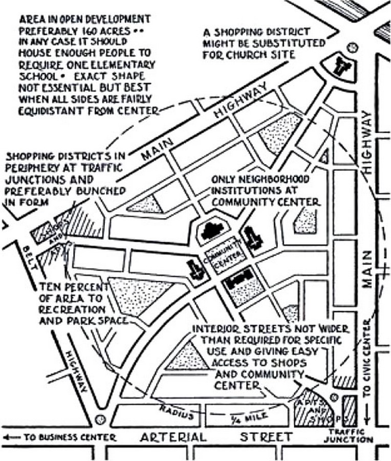
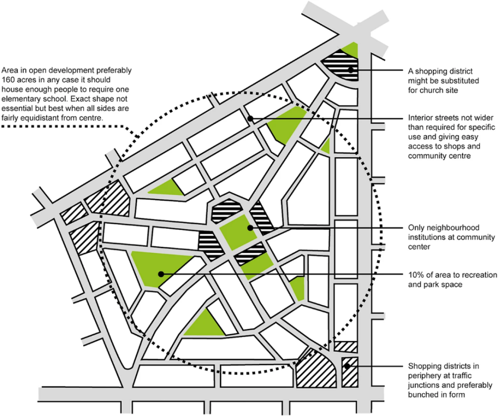
  4. Land Use Planning: A significant component of neighborhood planning is determining how land within the area should be used. This includes zoning decisions, the location of new homes, shops, or offices, and the protection of green spaces.
  5. Design Standards: Neighborhood plans often include design guidelines that ensure new developments are in harmony with the existing character of the area. This can include specifications for building height, materials, and architectural style.
  6. Implementation and Monitoring: Once a plan is adopted, it guides local government decisions on planning applications and development projects. The community also monitors progress and can make adjustments to the plan as needed.
  7. Legal Status: In many regions, neighborhood plans can become legally binding documents once they are approved through a community referendum and adopted by the local authority. This gives the plan significant influence over future development in the area.

Benefits of Neighborhood Planning:

  • Empowerment: Residents have a direct say in the development of their community.
  • Local Knowledge: Plans are more likely to reflect the unique needs and characteristics of the neighborhood.
  • Sustainable Development: Local input can help ensure that growth is sustainable and enhances the quality of life.
  • Conflict Reduction: Early community involvement can reduce conflicts over development decisions by addressing concerns upfront.

Challenges:

  • Resource Intensive: The process can be time-consuming and require significant effort from volunteers.
  • Complexity: Navigating planning regulations and technical details can be challenging for community groups.
  • Representation: Ensuring that the plan reflects the views of the entire community, including marginalized groups, can be difficult.

Overall, neighborhood planning is a powerful tool for local communities to shape their environment, fostering a sense of ownership and ensuring that development aligns with local needs and values.

References

Dehalwar, K. Bridging the Gap: Community-Based and Workshop-Based Approaches to Address Rural and Urban Planning Issues.

Dehalwar, K. (Ed.). (2024). Basics of Research Methodology-Writing and Publication. EduPedia Publications Pvt Ltd.

Lowndes, V., & Sullivan, H. (2008). How low can you go? Rationales and challenges for neighbourhood governance. Public administration86(1), 53-74.

Subhashini, M., & Wickramaarachchi, N. (2022). Applicability of Perry’s neighbourhood concept in neighbourhood planning in Sri Lanka. International Planning Studies27(4), 370-393.

Dehalwar, K., & Sharma, S. N. (2023). Fundamentals of Area Appreciation and Space Perceptions A Textbook for Students of Architecture and Planning. Notion Press. https://doi.org/10.5281/zenodo.13325383

Sharma, S. N., & Dehalwar, K. (2024). Fundamentals of Planning and Design of Housing A textbook for Undergraduate Students of Architecture and Planning. Notion Press. https://doi.org/10.5281/zenodo.13325661

Basic Concepts of Transit-Oriented Development (TOD)

Daily writing prompt
How do you plan your goals?

By Shashikant Nishant Sharma

Transit-Oriented Development (TOD) is an urban planning and design strategy that aims to create sustainable, livable, and efficient communities by integrating land use with transportation. The concept of TOD centers around the idea of building mixed-use, high-density neighborhoods that are well-connected by public transit, encouraging people to live, work, and play within walking distance of transit services. This approach reduces reliance on automobiles, lowers carbon emissions, and fosters more vibrant, equitable communities. Here’s a detailed explanation of the basic concepts of Transit-Oriented Development:

1. Proximity to Transit

  • Core Principle: TOD is typically centered around a major transit hub such as a train station, metro stop, or bus interchange. The area within a 5-10 minute walking radius (approximately 400-800 meters) from the transit hub is considered the TOD zone.
  • Pedestrian Accessibility: The design emphasizes pedestrian-friendly streetscapes that provide safe, convenient, and comfortable access to transit stations. Sidewalks, crosswalks, and public spaces are designed to prioritize walking over driving.

2. Mixed-Use Development

  • Diverse Land Use: TOD promotes a mix of residential, commercial, office, and recreational spaces within the same neighborhood. This reduces the need for long commutes and supports a more dynamic, 24-hour community.
  • Vertical Integration: Mixed-use buildings often combine residential units above and retail or office spaces below, maximizing land efficiency and creating a vibrant street-level experience.

3. High Density

  • Increased Density: TOD encourages higher population and employment densities in areas close to transit stations. This supports the viability of public transportation by ensuring a steady demand for services.
  • Zoning Regulations: Zoning laws and building codes are often adjusted in TOD areas to allow for higher density development, which can include taller buildings and smaller setbacks from the street.

4. Sustainable Urban Design

  • Environmentally Friendly: TOD aims to reduce urban sprawl by concentrating growth within already developed areas, preserving green spaces, and minimizing the environmental impact of development.
  • Energy Efficiency: Buildings in TOD areas are often designed with energy efficiency in mind, incorporating green building standards, sustainable materials, and renewable energy sources.

5. Public and Private Spaces

  • Vibrant Public Spaces: TOD projects typically include parks, plazas, and other public spaces that enhance the quality of life for residents and visitors. These spaces encourage social interaction and community building.
  • Private Amenities: In addition to public spaces, TOD developments often feature amenities like gyms, community centers, and retail options that cater to the daily needs of residents.

6. Reduced Dependence on Cars

  • Car Alternatives: TOD emphasizes reducing car dependency by providing robust public transportation options, along with bike-sharing programs, pedestrian paths, and carpool services.
  • Parking Management: Parking is strategically managed to discourage excessive car use, often through reduced parking minimums, shared parking structures, or even car-free zones.

7. Economic Benefits

  • Economic Development: TOD can spur economic growth by attracting investment in transit-adjacent areas, increasing property values, and creating jobs in construction, retail, and services.
  • Affordable Housing: To ensure equitable development, TOD strategies often include provisions for affordable housing, making it possible for people of different income levels to live near transit.

8. Social Equity

  • Inclusive Development: TOD aims to provide affordable and accessible transportation options to all residents, including low-income and marginalized communities, reducing transportation costs and improving access to jobs and services.
  • Community Engagement: Successful TOD projects involve the local community in the planning process, ensuring that development meets the needs and desires of current and future residents.

9. Integrated Transportation Planning

  • Multi-Modal Connectivity: TOD integrates various forms of transportation—such as buses, trains, bicycles, and walking—into a seamless network, allowing for easy and efficient movement within and between neighborhoods.
  • First and Last Mile Connectivity: Attention is given to the “first and last mile” of a person’s journey, ensuring that there are convenient ways to get to and from transit stations, such as bike lanes, pedestrian paths, and shuttle services.

10. Long-Term Vision and Planning

  • Strategic Planning: TOD requires a long-term vision, with careful planning and coordination among various stakeholders, including government agencies, private developers, and the community.
  • Phased Development: TOD projects are often implemented in phases, allowing for gradual growth and adaptation over time as the community evolves and as demand for transit increases.

Conclusion

Transit-Oriented Development is a holistic approach to urban planning that fosters sustainable growth by integrating transportation and land use. It promotes high-density, mixed-use neighborhoods with easy access to public transit, reducing car dependency, and enhancing quality of life. TOD is not just about transportation; it’s about creating vibrant, inclusive communities where people can live, work, and thrive with minimal environmental impact.

References

Dittmar, H., & Ohland, G. (Eds.). (2012). The new transit town: Best practices in transit-oriented development. Island Press.

Ibraeva, A., de Almeida Correia, G. H., Silva, C., & Antunes, A. P. (2020). Transit-oriented development: A review of research achievements and challenges. Transportation Research Part A: Policy and Practice132, 110-130.

Sharma, S. N., Kumar, A., & Dehalwar, K. (2024). The Precursors of Transit-oriented Development. EPW Economic & Political Weekly59(16), 14.

Thomas, R., Pojani, D., Lenferink, S., Bertolini, L., Stead, D., & Van der Krabben, E. (2018). Is transit-oriented development (TOD) an internationally transferable policy concept?. Regional Studies52(9), 1201-1213.

Eplanation of Core-Periphery Planning Theory

Daily writing prompt
How do you plan your goals?

By Kavita Dehalwar

Core-Periphery Planning Theory is a spatial-economic model that describes the relationship between economically developed regions (core) and less developed regions (periphery). This theory is often used in the context of regional development, urban planning, and economic geography. The core-periphery model explains how economic, social, and political power is concentrated in the core areas, leading to uneven development between the core and periphery. Below is a detailed discussion of the core-periphery planning theory:

1. Origins and Theoretical Foundation

  • Dependency Theory: Core-periphery theory is rooted in the broader dependency theory, which explains the global economic system as one where the core (developed countries) exploits the periphery (developing countries). This relationship is marked by unequal exchange and a flow of resources from the periphery to the core.
  • World Systems Theory: Immanuel Wallerstein’s World Systems Theory further elaborates on core-periphery dynamics, emphasizing the hierarchical structure of the global economy, where core countries dominate in production, finance, and technology, while peripheral countries are dependent on primary commodities and low-value-added industries.

2. Core-Periphery Model in Regional Development

  • Core Regions: These are economically advanced regions with high levels of industrialization, infrastructure, and urbanization. Core regions often serve as hubs for economic activities, political power, and cultural influence. Examples include major cities or industrialized regions within a country.
  • Periphery Regions: These regions are less developed, often characterized by lower income levels, inadequate infrastructure, and a dependence on primary sectors like agriculture or mining. Peripheral regions may struggle with issues such as outmigration, unemployment, and poor access to services.
  • Semi-Periphery: Some models introduce a semi-periphery category, which represents regions that are in transition between core and periphery. These areas might have emerging industries and infrastructure but still face challenges in fully integrating into the core.

3. Spatial Patterns and Processes

  • Polarization: The core-periphery model suggests that economic growth and development tend to be polarized, concentrating in core regions and leaving peripheral areas lagging. This can lead to increased inequalities between regions.
  • Circular Causation: Gunnar Myrdal’s concept of circular causation explains how initial advantages in core regions (e.g., better infrastructure, skilled labor) attract more investment, leading to further growth. Conversely, peripheral regions may experience a downward spiral due to a lack of investment.
  • Backwash Effects: This refers to the negative impacts on peripheral regions as resources, labor, and capital migrate to core regions. Peripheral areas may suffer from depopulation, deindustrialization, and a decline in economic opportunities.
  • Spread Effects: In contrast to backwash effects, spread effects describe the positive impacts that core regions can have on the periphery, such as through technology transfer, investment, and increased demand for peripheral products. However, these effects are often weaker than backwash effects.

4. Implications for Planning and Policy

  • Balanced Regional Development: One of the main objectives of planning in the context of core-periphery theory is to reduce regional disparities. Policies might include decentralizing industries, improving infrastructure in peripheral regions, and promoting regional development initiatives.
  • Growth Poles: A common strategy is to develop “growth poles” in peripheral regions—specific areas where investment and development are concentrated in the hope that growth will radiate outwards to surrounding areas.
  • Incentives and Subsidies: Governments may offer incentives, such as tax breaks or subsidies, to encourage businesses to invest in peripheral regions.
  • Infrastructure Development: Improving transportation, communication, and energy infrastructure in peripheral areas can help integrate them into the national and global economy, reducing the dominance of core regions.
  • 5. Criticisms and Challenges
  • Overemphasis on Economic Factors: Critics argue that the core-periphery model overly focuses on economic factors and may neglect social, cultural, and environmental dimensions of development.
  • Inequality Perpetuation: Some scholars contend that policies inspired by core-periphery theory may inadvertently reinforce existing inequalities by focusing too much on core areas or by failing to address the root causes of peripheral underdevelopment.

5. Criticisms and Challenges

  • Overemphasis on Economic Factors: Critics argue that the core-periphery model overly focuses on economic factors and may neglect social, cultural, and environmental dimensions of development.
  • Inequality Perpetuation: Some scholars contend that policies inspired by core-periphery theory may inadvertently reinforce existing inequalities by focusing too much on core areas or by failing to address the root causes of peripheral underdevelopment.
  • Globalization: The increasing interconnectedness of the world economy challenges traditional core-periphery dynamics. Some peripheral regions may bypass national cores and engage directly with global markets, leading to new patterns of development.

Applications in Urban and Regional Planning

  • Urban-Rural Divide: The core-periphery model is often applied to understand the urban-rural divide, where cities (core) dominate economically and socially over rural areas (periphery).

References

Borgatti, S. P., & Everett, M. G. (2000). Models of core/periphery structures. Social networks21(4), 375-395.

Baldwin, R. E. (2001). Core-periphery model with forward-looking expectations. Regional science and urban economics31(1), 21-49.

Currie, M., & Kubin, I. (2006). Chaos in the core-periphery model. Journal of Economic Behavior & Organization60(2), 252-275.

Sharma, S. N., Dehalwar, K., Kumar, G., & Vyas, S. (2023). Redefining Peri-urban Urban Areas. Thematics Journal of Geography12(3), 7-13.

Sharma, S. N., & Dehalwar, K. (2024). Fundamentals of Planning and Design of Housing A textbook for Undergraduate Students of Architecture and Planning. Notion Press. https://doi.org/10.5281/zenodo.13325661