The forces that influence ocean currents and their role in the fishing industry of the world

Introduction:

Ocean currents play a crucial role in the distribution of heat, nutrients, and marine life throughout the world’s oceans. These currents are driven by a variety of forces, including wind, temperature, and the Earth’s rotation. Understanding these forces and how they influence ocean currents is essential to many industries, including the fishing industry. In this article, we will explore the forces that influence ocean currents and their role in the fishing industry around the world.

Ocean Currents
Ocean Currents

Forces that influence ocean currents:

1. Wind:

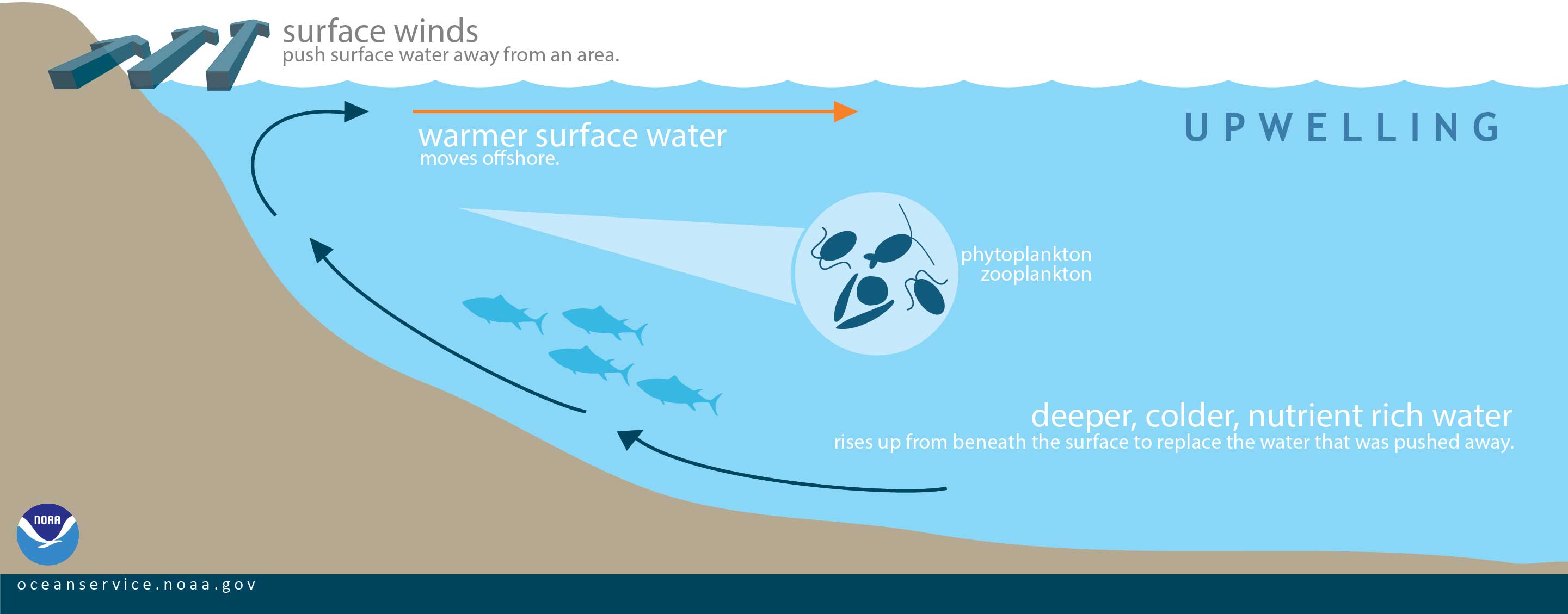
The wind is one of the primary forces that influence ocean currents. The wind creates surface currents, which are responsible for distributing heat and nutrients across the ocean. The wind also creates upwelling, which is the process by which deep, nutrient-rich water is brought to the surface. Upwelling is crucial to the fishing industry, as it provides an abundance of nutrients for marine life.

2. Temperature:

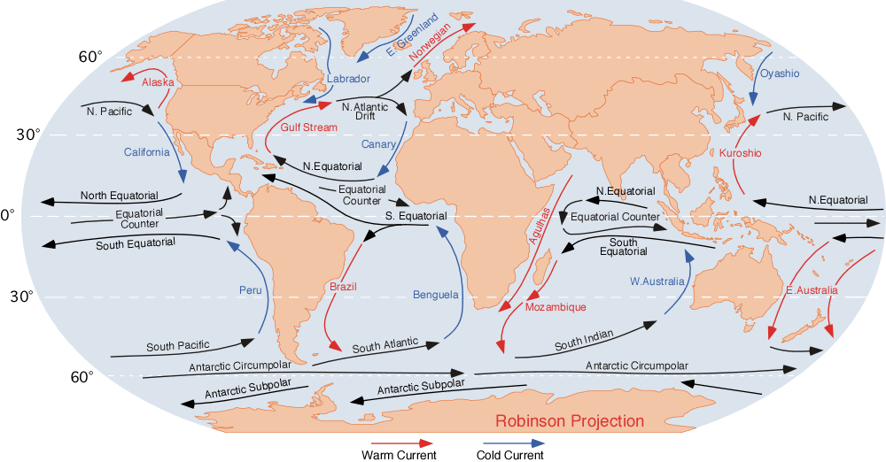
Temperature is another significant force that influences ocean currents. Warm water is less dense than cold water, so it tends to rise to the surface. This creates surface currents that move warm water away from the equator and towards the poles. Cold water, on the other hand, is dense than warm water and tends to sink. This creates deep ocean currents that move cold water toward the equator.

Temperature

3. Salinity:

Salinity, or the concentration of salt in the water, is another important force that influences ocean currents. When water evaporates, it leaves behind salt, which increases the salinity of the water. This increases the water’s density, causing it to sink and creating deep ocean currents. Areas of high salinity, such as the Mediterranean Sea, can also create surface currents that move water toward areas of lower salinity.

Salinity

4. The Earth’s rotation:

The Earth’s rotation also influences ocean currents. The Coriolis effect, which is caused by the rotation of the Earth, causes moving objects, including ocean currents, to appear to deflect to the right in the Northern Hemisphere and to the left in the Southern Hemisphere. This deflection causes ocean currents to move in a circular pattern, known as a gyre.

Earth's rotation

Role of ocean currents in the fishing industry:

Ocean currents play a crucial role in the fishing industry. The distribution of nutrients and marine life is influenced by ocean currents, which affect where fish are found and how abundant they are in different areas. Some of the most significant ways that ocean currents impact the fishing industry include:

1. Upwelling:

As mentioned earlier, upwelling is the process by which deep, nutrient-rich water is brought to the surface. This process is essential to the fishing industry, as it provides an abundance of nutrients for marine life. Areas of upwelling, such as the coasts of Peru and West Africa, are known for their rich fishing grounds.

Upwelling

2. Migration patterns:

Ocean currents also influence the migration patterns of fish. Some species of fish, such as salmon, are known to migrate long distances to reach their spawning grounds. Ocean currents can impact the timing and location of these migrations, which can affect the fishing industry’s ability to catch these fish.

Fish migration pattern

3. Fishing locations:

Ocean currents also influence where fish are found. Areas with high nutrient concentrations, such as upwelling zones, tend to have more abundant fish populations. The Gulf Stream, for example, is known for its rich fishing grounds, particularly for tuna and swordfish.

Fishing locations in oceans worldwide

4. Climate patterns:

Ocean currents also play a role in climate patterns. The movement of warm and cold water influences regional weather patterns, which can impact the fishing industry. Changes in ocean currents can also lead to changes in water temperature, which can affect the migration patterns and abundance of fish.

Climate patterns due to movement of earth

Conclusion:

In summary, the forces that influence ocean currents play a critical role in the fishing industry worldwide. Wind, temperature, salinity, and the Earth’s rotation all contribute to the distribution of nutrients and marine life in the world’s oceans. Upwelling, migration patterns, fishing locations, and climate patterns are all impacted by ocean currents and affect the fishing industry’s ability to catch fish. Understanding these forces and their role in ocean currents is essential to the fishing industry’s sustainability and success. As we continue to study and monitor these forces, we can better manage and protect our oceans’ resources for future generations.

Salient features of worldโ€™s physical geography.

Earth is splendid terrestrial haven. It is imperative to know physical geography through its display of environmental diversity. In scientific studies, it is established that Geography is a word that originated from two Greek roots. Geo-denotes to “Earth,” and graphy stands for “picture or writing.” Geography is the study of earth as the home of present day human being (Sagmit, 1998).The main objective of geography is the assessment, and explanation of Earth, its variability from place to place, the way places and features transform over time, and the processes responsible for these variations and changes. Geography is termed as the spatial science because it incorporates recognizing, analysing, and explaining the variations, similarities, or differences in phenomena situated on the surface of Earth. Geography is unique among the sciences by virtue of its characterization and central purpose. It describes the values and attitudes towards environment and sharpen intellectual and practice skill.

Earth’s structure is divided into three zones that include crust, Mantle and core. Crust is the solid outer layer of the Earth, and its depth is usually never more than 1 per cent of the Earth’s radius, or averaging 40โ€“50 km, but this varies significantly around the sphere. These are two different types: oceanic and continental. Mantle is the region within the Earth’s interior that range from 25 to 70 km below the surface, to a depth of ~2,900 km. It is composed mainly of silicate rocks, rich in iron and magnesium. At the base of the mantle, temperatures may reach up to 5,000ยฐC. These high temperatures may help to generate convection currents which drive plate tectonics. Core is the very centre of the Earth and is composed of iron and nickel. It consists of an outer core (semi-molten) and inner core (solid). The temperature at the very centre of the Earth (~6,300 km below surface) may reach 5,500ยฐC.

Geography is inherently encompassing discipline. It brings together facts from other sciences such as physical biological and social. Physical geography is related to the physical science. Physical geography includes the processes and attributes that constitute Earth which incorporate human activities where they interface with the atmosphere. Different branches of Physical geography are climatology, Meteorology, Geomorphology and pedageography (Sagmit, 1998).Scientific studies have revealed that physical geographers are more interested in comprehending all aspects of Earth and can be considered generalists because they are qualified to scrutinize a natural environment in its entirety, and how it functions as a unit. In physical geography, researchers study about lithosphere, atmosphere, hydrosphere, and biosphere. Due to interaction of these elements, numerous changes occur on earth surface. Most physical geographers concentrate on advanced study in one or two specialties. For instance, meteorologists and climatologists believe how the interaction of atmospheric components influences weather and climate. Meteorologists focus their studies learning the atmospheric processes that affect daily weather, and they use current data to predict weather conditions. Climatologists are interested in the averages and extremes of long-term weather data, regional classification of climates, monitoring and understanding climatic change and climatic hazard, and the long term impact of atmospheric conditions on human actions and the surroundings.

The factors involved in landform development are as varied as the environments on Earth, and include gravity, running water, stresses in the Earth’s crust, flowing ice in glaciers, volcanic activity, and the erosion or deposition of Earth’s surface materials. Biogeographers scrutinize natural and human-modified environments and the ecological processes that influence their characteristics and distributions, including vegetation change over time. They also research and explain the ranges and patterns of vegetation and animal species, seeking to find out the environmental factors that limit or facilitate their distributions. Several soil scientists are geographers, who are concerned in mapping and analysing soil types, determining the aptness of soils for certain uses, such as agriculture, and working to conserve soil as a natural resource. Geographers are broadly concerned to study water bodies and their processes, movements, impact, quality, and other features. They may serve as hydrologists, oceanographers, or glaciologists. Many geographers involved with water studies also function as water resource managers, who work to ensure that lakes, watersheds, springs, and groundwater sources are suitable to meet human or environmental needs, provide an adequate water supply, and are as free of pollution as possible. Hydrology is merging science. It helps to understand the processes in which water plays an important role in nature through oceans, rivers and glaciers in sustaining life forms of earth surface.


IN OUR CHANGING WORLD NOTHING CHANGES MORE THAN GEOGRAPHY

Global Warming

Global warmingโ€™ is the term used to describe the rise in global surface temperatures. The term is often used interchangeably with โ€˜climate changeโ€™. The phenomenon revolves around the rise in surface temperatures โ€“ over land and oceans โ€“ that have led to an accelerated increase in temperatures. This has in turn led to the progressive shrinkage of the glaciers and polar ice caps, leading to rise in sea level. Another observed effect has been the disruption of cyclical weather patterns and the rising number of freak natural disasters.

The rise in temperatures has been attributed to the build-up of greenhouse gases, such as carbon dioxide and methane, at especially accelerated levels as a result of the industrialisation of the past 100 years. A concerted global effort to counter and mitigate the effects of this phenomenon has been elusive, with developed nations and developing countries facing off over the respective levels of emission cuts they would have to effect domestically.

However, there is also a considerable minority, especially in the US, that holds the assumption that global warming as a hoax perpetrated by certain countries for their own benefit.

Climate change: Everyone Focused on saving lives till now, time to save livelihood as well:

According to a Climate Central map, hundreds of cities on Indiaโ€™s eastern coast will be under water by 2050. CEEW says more than 80% of Indiaโ€™s population is vulnerable to โ€œextreme climate risksโ€

According to a map created by Climate Central, hundreds of cities on the eastern coast of India will be under water by the year 2050. Over 27 states and union territories in India and more than 80% of the countryโ€™s population are vulnerable to โ€œextreme climate risksโ€, says a report by the Council on Energy, Environment and Water.

These statistics show that the lives of many communities are put in danger due to climate change, and that a significant number of them lose their livelihood to it as well. Ritayan Mukherjee, a photojournalist, shares that while covering the pastoral nomads in the Himalayas, he came across the Changpa community who take their yak and sheep to grazing grounds that are 10,000-11,000 feet above the sea level. โ€œThe livelihood of these people is directly dependent on nature, because they move with their herd from one place to another,โ€ says he.


Mukherjee shares that because of global warming, rising temperatures and the winter months getting shorter, the pastoralists have to take their herds to even higher grazing grounds. A report that Mukherjee worked on for the Peopleโ€™s Archive of Rural India said that the yak population in Leh fell about 57% between 1991-2010, according to the Department of Animal Husbandry and Dairying. A lot of these pastoralists donโ€™t just depend on yak for their economic incomes, but they also use the yak-wool to build traditional tents, called Rebos. However, Mukherjee shares that these residential tents have disappeared over the past few years for reasons that can be attributed to climate change.

According to a Climate Central map, hundreds of cities on Indiaโ€™s eastern coast will be under water by 2050. CEEW says more than 80% of Indiaโ€™s population is vulnerable to โ€œextreme climate risksโ€.

How many headlines and news articles did you come across in the last month that told you the condition of the climate is deteriorating? That a big chunk of our lives will be lost battling global warming in the next few decades? Itโ€™s no secret that climate change is impacting lives every single day, but letโ€™s take a look at how it has been affecting us and what we can do to change its course.

GUANO ISLANDS

Guano islands were discovered on a series of islands off the coast of Peru. These islands are rocky and barren and have no vegetation owning to lack of rain in the area.

The word ‘GUANO’ originated from the Andean indigenous language Quechua, which refers to any form of dung used as a fertilizer in agriculture. So what is guano? Dropping of certain fish eating birds are called as guano. Three birds are primarily producers of guano- white breasted cormorants, grey pelicans and white head gannets or piqueros. Millions of this types of birds reside on these islands because of this island isolation from natural predators and large reserves of anchovy fishes. Due to lack of rain their dropping gets baked in the dry atmosphere preventing nitrates in these droppings from evaporating make it a good fertilizer. Over the course of years guano reserves have accumulated into a thick layer of 100-150 feet guano fertilizer.

Guano has valuable agricultural benefits as it’s a natural fertilizer the crop yields improved which made it high prized commodity during 19th century. It was heavily traded by the European and American traders. It helped to build Peru economy. It Haas been estimated that around mid 1800’s Peruvian excavated over 20,000,000 tons of guano making a huge profit. Eventually Peru suffered a loss due depleted guno and introduction of artificial fertilizers.

Since 1909, the Peruvian government has taken measures to conserve guano reserves by establishing the GUANO ADMINISTRATION COMPANY . The methods includes;

. Keeping the islands off limits to reacumulate their guano reserves and not disturbing the natural habitat of these birds.

. Controlling the commercial fishing industry and setting measures to conserve guano birds feeds.

. Establishing preservation parks on the main land where some birds can migrate so that they can be safe from predators.

. Limiting guano exports and preventing disruption of ocean ecosystem.

Geographers and Uses of GIS

By Shashikant Nishant Sharma

Geographers often find it beneficial to understand GIS (Geographic Information System) algorithms, but it’s not always a strict requirement for all geographers. GIS is a powerful tool that allows geographers to analyze and interpret spatial data, and a basic understanding of GIS algorithms can enhance their ability to use GIS effectively. Here are a few reasons why geographers might benefit from understanding GIS algorithms:

  1. Better Use of GIS Software: Understanding the algorithms behind GIS software can help geographers make more informed decisions when choosing and utilizing specific tools. It enables them to select appropriate methods for data analysis and visualization.
  2. Customization and Problem Solving: A deeper understanding of GIS algorithms allows geographers to customize workflows and address specific spatial analysis problems more effectively. This knowledge empowers them to develop solutions tailored to their research or professional needs.
  3. Interpretation of Results: Knowing the algorithms applied in GIS helps geographers interpret the results of spatial analyses more accurately. This understanding allows them to critically evaluate the outcomes and make informed decisions based on a deeper comprehension of the underlying processes.
  4. Integration with Other Technologies: Geographers working at the intersection of GIS and other technologies, such as remote sensing or machine learning, may benefit from understanding the algorithms that drive these technologies. It facilitates integration and synergy between different tools and methods.
  5. Algorithm Development: Some geographers may engage in algorithm development for specific spatial analysis tasks. In such cases, a solid understanding of GIS algorithms is essential for creating effective and efficient solutions.

However, it’s important to note that not all geographers need to delve deeply into GIS algorithms. Many geographers use GIS as a tool for spatial analysis without needing to understand the underlying algorithms at a detailed level. The level of understanding required depends on the specific tasks and goals of the geographer. Some may focus more on the conceptual and applied aspects of GIS, while others, especially those involved in GIS development or research, may need a more in-depth understanding of algorithms.

References

Abler, R. F. (1993). Everything in its place: GPS, GIS, and geography in the 1990s.ย The Professional Geographer,ย 45(2), 131-139.

Goodchild, M. F. (2004). GIScience, geography, form, and process.ย Annals of the Association of American Geographers,ย 94(4), 709-714.

Healy, G., & Walshe, N. (2019). Real-world geographers and GIS.ย Teaching Geography,ย 44(2), 52-55.

Johnston, R. J. (1999). Geography and GIS.ย Geographical information systems: Principles, techniques, management and applications,ย 1, 39-47.

Sharma, S. N. (2019). Review of most used urban growth models.ย International Journal of Advanced Research in Engineering and Technology (IJARET),ย 10(3), 397-405.