
Hydrology is a branch of Earth Science. The importance of hydrology in the assessment, development, utilisation and management of the water resources, of any region is being increasingly realised at all levels. It was in view of this that the United Nations proclaimed the period of 1965-1974 as the International Hydrological Decade during which, intensive efforts in hydrologic education research, development of analytical techniques and collection of hydrological information on a global basis, were promoted in Universities, Research Institutions, and Government Organisations.
WORLD’S WATER RESOURCES
The World’s total water resources are estimated at 1.36 × 10⁸ Μ ha-m. Of these global water resources, about 97.2% is salt water mainly in oceans, and only 2.8% is available as fresh water at any time on the planet earth. Out of this 2.8% of fresh water, about 2.2% is available as surface water and 0.6% as ground water. Even out of this 2.2% of surface water, 2.15% is fresh water in glaciers and icecaps and only of the order of 0.01% is available in lakes and streams, the remaining 0.04% being in other forms. Out of 0.6% of stored ground water, only about 0.25% can be economically extracted with the present drilling technology (the remaining being at greater depths).

WATER RESOURCES OF INDIA
The important rivers of India and their approximate water potentials are given below:
- West flowing rivers like Narmada and Tapti – 30.55 (M ha-m)
- East flowing rivers like Mahanadi, – Godavari, (M ha-m)
- Krishna, Cauvery and Pennar – 35.56 (M ha-m)
- The Ganges and its tributaries – 55.01 (M ha-m)
- Indus and its tributaries – 7.95 (M ha-m)
- The River Brahmaputra – 59.07 (M ha-m)

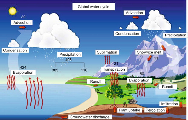
HYDROLOGIC CYCLE
Hydrologic cycle is the water transfer cycle, which occurs continuously in nature; the three important phases of the hydrologic cycle are: (a) Evaporation and evapotranspiration (b) precipitation and (c) runoff. The globe has one-third land and two-thirds ocean. Evaporation from the surfaces of ponds, lakes, reservoirs. ocean surfaces, etc. and transpiration from surface vegetation i.e., from plant leaves of cropped land and forests, etc. take place. These vapours rise to the sky and are condensed at higher altitudes by condensation nuclei and form clouds, resulting in droplet growth. The clouds melt and sometimes burst resulting in precipitation of different forms like rain, snow, hail, sleet, mist, dew and frost. A part of this precipitation flows over the land called runoff and part in-filters into the soil which builds up the ground water table. The surface runoff joins the streams and the
water is stored in reservoirs. A portion of surface runoff and ground water flows back to ocean. Again evaporation starts from the surfaces of lakes, reservoirs and ocean, and the cycle repeats.
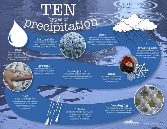
FORMS OF PRECIPITATION
- Drizzle — a light steady rain in fine drops (0.5 mm) and intensity (<1 mm/hr) Rain the condensed water vapour of the atmosphere falling in drops (>0.5 mm, maximum size—6 mm) from the clouds.
- Glaze — Freezing of drizzle or rain when they come in contact with cold objects.
- Sleet — Frozen rain drops while falling through air at subfreezing temperature.
- Snow — Ice crystals resulting from sublimation (i.e., water vapour condenses to ice)
- Snow flakes — Ice crystals fused together.
- Hail — Small lumps of ice (>5 mm in diameter) formed by alternate freezing and melting, when they are carried up and down in highly turbulent air currents.
- Dew — Moisture condensed from the atmosphere in small drops upon cool
surfaces. - Frost — A feathery deposit of ice formed on the ground or on the surface of exposed objects by dew or water vapour that has frozen.
- Fog — A thin cloud of varying size formed at the surface of the earth by condensation of atmospheric vapour.
- Mist — Avery thin fog.
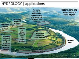
SCOPE OF HYDROLOGY
The study of hydrology helps us to know;
- The maximum probable flood that may occur at a given site and its frequency; this is required for the safe design of drains and culverts, dams and reservoirs, channels and other flood control structures.
- The water yield from a basin—its occurrence, quantity and frequency, etc; this is necessary for the design of dams, municipal water supply, water power, river navigation, etc.
- The ground water development for which a knowledge of the hydro-geology of the area, i.e., of the formation soil, recharge facilities like streams and reservoirs, rainfall pattern, climate, cropping pattern, etc. are required.
- The maximum intensity of storm and its frequency for the design of a drainage project in the area.
A hydrologist is often posed with lack of adequate data. The basic hydrological data required are:
- Climatological Data.
- Hydro meteorological data like temperature, wind velocity, humidity, etc.
- Precipitation records and Stream-flow records.
- Seasonal fluctuation of ground water table and evaporation data.
- Cropping pattern, crops and their consumptive use water quality data of surface streams and ground water
- Geomorphologic studies of the basin, like area, shape and slope of the basin, mean and median elevation, mean temperature (as well as highest and lowest temperature recorded) and other physiographic characteristics of the basin; stream density and drainage density; tanks and reservoirs
Hydro-meteorological characteristics of basin:
- Depth-area-duration (DAD) curves for critical storms.
- Isohyetal maps—Isohyets may be drawn for long-term average, annual and monthly precipitation for individual years and months.
- Cropping pattern crops and their seasons.
- Daily, monthly and annual evaporation from water surfaces in the basin.
- Water balance studies of the basin
- Soil conservation and methods of flood control
Hydrology means the science of water. It is the science of the water that deals with the occurrence , circulation and distribution of water of the earth and earth’s atmosphere. As a branch of earth science, it is concerned with the water in the streams and lakes, rainfall and snow fall, snow and ice on the land and water occurring below the earth’s surface in the pores of rocks ans soils.

You must be logged in to post a comment.