
By Shashikant N Sharma
Abstract
The rapid growth of cities, increasing travel demand, congestion, environmental degradation, road-safety risks, and pressure on urban infrastructure have created a need for more intelligent and adaptive approaches to urban management. Artificial intelligence (AI), Internet of Things (IoT), digital twins, geospatial technologies, and intelligent transportation systems are increasingly transforming the way cities understand, plan, and manage mobility. Rather than treating transportation as an isolated infrastructure sector, smart-city planning increasingly requires integration between land use, transport, human behaviour, environmental conditions, infrastructure, and real-time data. This article examines the emerging role of AI, digital twins, and intelligent mobility in smart cities, with particular emphasis on transportation planning, transit-oriented development (TOD), travel behaviour, first- and last-mile accessibility, road safety, urban growth, and sustainable logistics. Drawing upon recent research on AI-based mobility modelling, digital twins, TOD, transportation planning, road safety, and urban sustainability, the article proposes an integrated conceptual framework in which sensing, data integration, AI-based prediction, digital-twin simulation, and intelligent decision-making form a continuous urban mobility intelligence cycle. The article also discusses challenges involving data quality, interoperability, privacy, explainability, institutional capacity, digital inequality, and implementation in developing and Tier-2 cities. It concludes that AI and digital twins should be understood not merely as technological tools but as components of a broader planning ecosystem linking physical infrastructure, human behaviour, environmental sustainability, and evidence-based urban governance.
Keywords: Artificial intelligence; digital twins; intelligent mobility; smart cities; urban transportation; transit-oriented development; travel behaviour; machine learning; urban planning; sustainable mobility; digital transformation; intelligent transportation systems
1. Introduction
Cities are increasingly complex socio-technical systems in which land use, transportation, infrastructure, economic activity, environmental conditions, and human behaviour interact continuously. Rapid urbanization has intensified congestion, automobile dependence, road-safety concerns, air pollution, infrastructure pressure, and unequal access to opportunities. Conventional planning approaches, which often rely on static datasets and periodic surveys, are increasingly challenged by the dynamic nature of contemporary urban systems.
The emergence of artificial intelligence (AI), Internet of Things (IoT), big-data analytics, geographic information systems (GIS), and digital twins provides new possibilities for understanding and managing this complexity. Recent systematic research demonstrates that the convergence of AI, AIoT, and urban digital twins is creating new possibilities for data-driven urban planning and sustainable smart-city development.
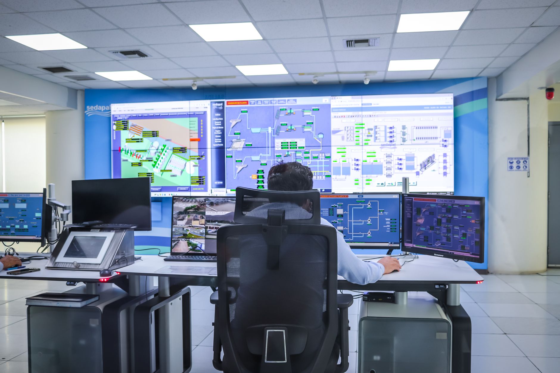
This transformation is particularly important in urban mobility. Transportation systems generate enormous volumes of spatial and temporal information through GPS devices, mobile phones, smart cards, traffic sensors, cameras, connected vehicles, public-transport systems, and increasingly connected infrastructure. AI can convert these heterogeneous data into predictions and recommendations, while digital twins can provide dynamic representations of urban transportation systems in which alternative scenarios can be simulated before interventions are implemented.
The relevance of these technologies is reflected in the growing body of research on intelligent mobility and urban transportation. Sharma and Dehalwar’s work on AI-based mobility modelling identifies the growing importance of intelligent modelling for smart-city transportation systems (Sharma & Dehalwar, 2026). Their research contributes to a broader transition from conventional transportation models towards data-driven and adaptive mobility analysis. The literature on digital twins similarly shows a shift from static digital representation towards dynamic systems capable of monitoring, prediction, simulation, and optimization. Recent reviews identify digital twins as increasingly important for transport planning, although challenges concerning interoperability, empirical validation, and institutional integration remain.
The objective of this article is therefore to examine how AI, digital twins, and intelligent mobility can be integrated within smart-city planning. Particular attention is given to the relationship between transportation and land use, travel behaviour, TOD, first- and last-mile accessibility, safety, sustainable logistics, and urban resilience.
2. From Smart Cities to Intelligent Mobility
The concept of the smart city has evolved substantially. Early smart-city initiatives frequently emphasized ICT infrastructure, connectivity, and digital service delivery. Contemporary approaches increasingly focus on the integration of technology with sustainability, resilience, inclusivity, and evidence-based governance.
Mobility is central to this transformation because transportation connects people to employment, education, healthcare, public services, housing, and other opportunities. Consequently, smart mobility should not simply mean deploying sensors or automating traffic signals. It should involve improving accessibility, reducing unnecessary travel, supporting sustainable modes, increasing safety, and enabling more equitable access to urban opportunities.
Research on transit-oriented development illustrates this broader perspective. Sharma and Dehalwar’s systematic literature review identifies TOD as an important planning approach for linking transportation investment with urban development and economic outcomes (Sharma & Dehalwar, 2025). Their earlier work on the precursors of TOD further emphasizes the historical and planning conditions that influence transit-oriented urban development (Sharma et al., 2024).
The relationship between land use and transportation is particularly important. Sharma and Dehalwar’s review of land-use transportation interaction models demonstrates the significance of integrated modelling for smart urban growth management (Sharma & Dehalwar, 2025). Rather than modelling transport independently from urban development, integrated systems can examine how changes in density, accessibility, employment distribution, infrastructure, and land use influence travel behaviour.
This integrated perspective is essential for AI-enabled smart cities. AI models can identify complex relationships within large datasets, but their effectiveness depends on the quality and contextual interpretation of the data. A technically accurate prediction that ignores urban morphology, socioeconomic conditions, infrastructure constraints, or behavioural responses may still produce poor planning outcomes.
3. Artificial Intelligence in Urban Mobility
AI is increasingly being applied across the transportation lifecycle, including demand prediction, mode-choice modelling, route optimization, congestion forecasting, traffic management, road-safety analysis, public-transport operations, and logistics.
Machine learning models can identify nonlinear relationships that may be difficult to capture using traditional statistical techniques. Sharma and Dehalwar’s work on AI-based mobility modelling highlights the potential of AI for intelligent transport infrastructure and smart-city applications (Sharma & Dehalwar, 2026). Similarly, recent research indicates that AI applications in urban transportation increasingly encompass congestion prediction, safety analytics, intelligent transportation systems, and sustainable mobility planning.
3.1 AI and travel behaviour
Travel behaviour is one of the most important components of intelligent mobility. Transportation infrastructure alone does not determine travel outcomes. Individuals make decisions concerning mode, route, destination, departure time, and trip frequency based on accessibility, cost, convenience, safety, weather, built environment, socioeconomic characteristics, and personal preferences.
Research on travel behaviour in TOD environments demonstrates the importance of understanding these behavioural dimensions. Sharma and Dehalwar’s work on travel behaviour modelling using Partial Least Squares Structural Equation Modelling provides evidence of the value of behavioural and perceptual variables in understanding TOD-based travel patterns (Sharma & Dehalwar, 2026). Their systematic review of travel-behaviour modelling further emphasizes the importance of methodological development in this field (Sharma et al., 2026).
AI can extend such approaches by combining behavioural surveys with large-scale mobility datasets. For example, machine-learning models can integrate demographic characteristics, land-use variables, transit accessibility, network characteristics, weather conditions, and observed travel patterns.
However, AI should complement rather than automatically replace behavioural theory. Black-box prediction can identify correlations without explaining why a particular behaviour occurs. Consequently, explainable AI (XAI), interpretable machine learning, and hybrid approaches combining behavioural theory with machine learning are increasingly relevant.
3.2 AI and mode choice
Mode choice is another critical application. The decision to use a private automobile, bus, metro, bicycle, walking, ride-hailing, or another mode influences congestion, energy consumption, emissions, and public-space requirements.
Research on bus-user satisfaction in Bhopal demonstrates the importance of user perceptions in public-transport planning (Lodhi et al., 2024). Such research can be complemented by AI models that analyse large volumes of passenger feedback, trip data, service frequency, travel times, and network accessibility.
The integration of discrete-choice models and machine learning is particularly promising. Traditional choice models provide interpretability and behavioural structure, whereas machine-learning approaches can capture nonlinear relationships. Combining both can create more useful decision-support systems for planners.
4. Digital Twins as the Intelligence Layer of Smart Mobility
A digital twin can be understood as a dynamic digital representation of a physical system that is continuously connected to data from its real-world counterpart. In transportation, a digital twin may represent a road network, public-transport system, intersection, corridor, vehicle fleet, neighbourhood, or entire metropolitan mobility system.
The distinction between a conventional digital model and a digital twin is important. A static model may represent a transportation system, whereas a digital twin is designed to maintain a dynamic relationship with the physical system. Recent transport research describes digital twins as increasingly capable of monitoring, prediction, simulation, optimization, decision support, and resilience management.
A recent review of public-bus digital twins similarly identifies real-time monitoring, simulation, optimization, AI integration, and human-computer interaction as major dimensions of digital-twin development in public transportation.
The potential of digital twins becomes particularly significant when combined with AI. AI can provide the analytical “brain” while the digital twin provides the dynamic environment in which predictions and scenarios can be evaluated. This combination allows planners to move from retrospective analysis towards predictive and potentially prescriptive planning.
5. AI–Digital Twin Integration
An integrated AI–digital twin architecture can be conceptualized through five interconnected layers:
- Physical urban system: roads, transit stations, vehicles, pedestrians, buildings, land uses, and infrastructure.
- Sensing and data layer: IoT sensors, GPS, smart cards, cameras, GIS, remote sensing, mobile data, and administrative datasets.
- Digital-twin layer: dynamic representation of the transportation and urban system.
- AI and analytics layer: machine learning, deep learning, optimization, forecasting, anomaly detection, and decision-support algorithms.
- Planning and governance layer: interventions, policy evaluation, stakeholder engagement, monitoring, and feedback.
The system operates as a continuous feedback cycle rather than a one-way information pipeline.
For example, a city may detect increasing congestion near a transit station. Real-time data are transferred to the digital twin. AI predicts how congestion may develop under alternative conditions. The digital twin simulates interventions such as signal optimization, bus-priority lanes, pedestrian improvements, parking restrictions, or changes in transit frequency. Planners can compare the simulated consequences before implementation. After an intervention is implemented, new observations are fed back into the system.
Recent literature supports this integrated perspective. A systematic review of AI, AIoT, and urban digital twins found that their convergence can strengthen data-driven environmental planning and urban management, while also identifying major challenges involving interoperability, implementation, and governance.
6. Digital Twins and Transit-Oriented Development
TOD represents an especially promising application domain for digital twins because it requires simultaneous consideration of land use, transportation, accessibility, pedestrian movement, public transport, economic activity, and urban form.
Sharma and Dehalwar’s research on TOD and economic development emphasizes the relationship between transit-oriented development and broader urban-economic outcomes (Sharma & Dehalwar, 2025). Their work on first- and last-mile accessibility further demonstrates that access to transit cannot be assessed simply by measuring distance to a station. Accessibility depends on infrastructure, environmental conditions, network characteristics, safety, user characteristics, and available modes (Yadav et al., 2025).
A TOD digital twin could integrate:
- transit routes and schedules;
- pedestrian networks;
- cycling infrastructure;
- station catchment areas;
- land-use patterns;
- population and employment;
- traffic flows;
- first- and last-mile modes;
- environmental conditions;
- accessibility indicators; and
- user behaviour.
This would allow planners to test alternative TOD scenarios before implementation.
For example, a planner could simulate whether increasing density around a transit station without improving pedestrian infrastructure would create accessibility problems. Similarly, alternative locations for pedestrian crossings, cycleways, feeder services, parking facilities, or bus stops could be evaluated.
Recent work by Yadav, Dehalwar, and Sharma on machine-learning-based multimodal accessibility in TOD zones demonstrates the growing potential for combining AI with accessibility assessment in Tier-2 Indian cities (Yadav et al., 2026). Their work on environmental determinants of first- and last-mile mode choice further highlights the need to account for climate and environmental conditions in mobility modelling (Yadav et al., 2026).
7. Intelligent Mobility and First- and Last-Mile Connectivity
The first and last mile remains one of the most important challenges in public transportation. A city may have an extensive rail or bus network, but poor access between residences, workplaces, public spaces, and stations can reduce the usefulness of the entire system.
Research by Yadav, Dehalwar, and Sharma systematically examines factors affecting first- and last-mile accessibility in TOD environments (Yadav et al., 2025). Related research investigates environmental determinants of mode choice and climate-sensitive user satisfaction in Tier-2 Indian cities (Yadav et al., 2026; Yadav et al., 2025).
AI can contribute by predicting first- and last-mile demand, identifying underserved areas, optimizing feeder services, and assessing pedestrian and cycling accessibility.
Digital twins can then simulate how improvements affect the wider system. A new feeder route, for example, could be tested against changes in transit demand, congestion, emissions, walking distance, and network accessibility.
This approach is particularly important in developing cities, where financial resources for infrastructure are limited and interventions must be carefully targeted.
8. AI and Road Safety
Road safety is another major domain for intelligent mobility. Conventional safety analysis frequently depends on historical crash data. Although crash records are essential, they provide information only after an unsafe event has occurred.
Sharma, Singh, and Dehalwar’s work on surrogate safety analysis demonstrates the potential of advanced technologies for moving towards more proactive approaches to road safety (Sharma et al., 2024). Surrogate safety measures can use near-miss events, vehicle trajectories, speed variations, conflicts, and other indicators to identify potentially hazardous situations.
AI can analyse video, sensor, and trajectory data to identify unsafe interactions between vehicles, pedestrians, and cyclists. Digital twins can then reproduce these conditions within a virtual environment and test potential interventions.
The combination of AI and digital twins therefore creates a pathway from:
observation → detection → prediction → simulation → intervention → evaluation.
Such a system could support safer intersection design, adaptive traffic control, pedestrian infrastructure planning, and proactive risk management.
Research on mid-block traffic analysis further illustrates the relevance of detailed traffic-system analysis for road safety (Sharma & Singh, 2023). These approaches can become more powerful when integrated into real-time digital-twin environments.
9. Intelligent Mobility and Sustainable Last-Mile Logistics
Urban logistics represents another major challenge for smart cities. E-commerce growth, delivery services, and changing consumer behaviour have increased the volume of last-mile freight movements.
Recent research by Sharma on generative AI and digital twins for sustainable last-mile logistics examines the potential of emerging digital technologies to support green operations and electric-vehicle integration (Sharma, 2026). Related work addresses digital-twin-driven optimization and sustainable last-mile logistics (Sharma, 2026).
AI can support delivery-demand prediction, vehicle-routing optimization, fleet management, charging coordination, and consolidation planning. Digital twins can simulate the consequences of alternative logistics strategies across an urban network.
For example, a city could evaluate the effects of delivery consolidation centres, electric delivery fleets, restricted delivery periods, cargo-bike systems, or dynamic routing. Rather than evaluating each intervention independently, a digital twin can model interactions between freight, passenger traffic, road capacity, emissions, and land use.
This is particularly important because freight and passenger mobility increasingly compete for the same limited urban road space.
10. AI, Digital Twins and Urban Growth
Intelligent mobility cannot be separated from urban growth. Urban expansion changes travel distances, accessibility patterns, infrastructure requirements, and transport demand.
Research using cellular automata and artificial neural networks for predicting urban growth in Indore demonstrates how spatial modelling and AI can contribute to planning-policy analysis (Kumar et al., 2025). Similarly, Sharma’s review of urban growth models identifies the importance of modelling approaches for understanding future urban development (Sharma, 2019).
The integration of urban-growth models with digital twins could enable planners to simulate alternative development trajectories. For example, different growth scenarios could be evaluated according to their consequences for:
- transport demand;
- infrastructure costs;
- accessibility;
- urban sprawl;
- environmental quality;
- public-transport viability;
- housing;
- energy consumption; and
- road safety.
This represents an important shift from simply predicting urban growth to evaluating the consequences of alternative urban futures.
11. Environmental Sustainability and Intelligent Mobility
Transportation is closely linked to environmental sustainability. Congestion, vehicle emissions, energy consumption, urban heat, stormwater impacts, and land consumption are interconnected.
Research on sustainable urban development, green buildings, stormwater management, and urban environmental conditions demonstrates the importance of integrated planning. Sharma et al.’s work on green buildings and sustainable neighbourhoods, for example, links built-environment interventions with broader sustainability goals (Sharma et al., 2025). Research using SWMM and GIS for stormwater management demonstrates the potential of integrated spatial and computational approaches to urban environmental management (Patel et al., 2024).
Digital twins can integrate mobility with environmental information. Traffic emissions can be linked to road networks, land use, meteorological conditions, and population exposure. AI can predict pollution hotspots, while the digital twin can test alternative mobility scenarios.
The integration of AI, IoT, and urban digital twins has been identified in recent systematic literature as an important direction for data-driven environmental planning.
12. Digital Twins for Urban Resilience
Smart mobility systems must also be resilient to disruptions. Flooding, extreme weather, accidents, infrastructure failures, public-health emergencies, and other disruptions can affect transportation networks.
Recent systematic research indicates that digital twins can support resilience through real-time visibility, disruption anticipation, scenario simulation, dynamic optimization, decision support, service continuity, and post-disruption learning.
This has particular relevance for cities facing climate-related risks. Sharma and Dehalwar’s work on nature-based solutions and delta resilience highlights the importance of integrating environmental resilience with sustainable urban development (Sharma & Dehalwar, 2026). A mobility digital twin could incorporate flood-prone roads, evacuation routes, public-transport capacity, emergency services, and alternative travel paths.
Consequently, digital twins can become resilience-management platforms rather than merely visualization systems.
13. Challenges and Limitations
Despite their potential, AI and digital twins should not be considered automatic solutions to urban problems.
13.1 Data quality
AI models are highly dependent on the quality and representativeness of training data. Incomplete or biased datasets can generate unreliable predictions. This is particularly significant in developing and Tier-2 cities where continuous high-resolution datasets may not be available.
13.2 Interoperability
Urban data originate from multiple agencies and platforms. Transport, land-use, utilities, environmental monitoring, emergency management, and municipal systems may use different standards. Interoperability therefore represents a major requirement for city-scale digital twins.
Recent reviews consistently identify interoperability as a persistent challenge in smart-city digital-twin implementation.
13.3 Explainability
Transportation decisions can affect people’s everyday lives. AI systems that recommend changes to routes, traffic controls, accessibility, or resource allocation therefore require appropriate levels of transparency.
Explainable AI is particularly important where algorithmic recommendations influence public investment or mobility access.
13.4 Privacy and ethics
Mobility datasets can contain highly sensitive information about people’s movements. Location traces, smart-card records, mobile-phone data, and connected-vehicle information therefore require appropriate privacy protections.
13.5 Digital inequality
Smart-city technologies may unintentionally favour digitally connected populations. An intelligent mobility system should not equate digital participation with universal accessibility. Offline users, elderly people, persons with disabilities, low-income households, and people with limited digital literacy must remain part of the planning process.
Research examining inclusivity in India’s National Urban Transport Policy and universal design further reinforces the importance of equity within planning and mobility systems (Sharma & Dehalwar, 2025; Agarwal & Sharma, 2014).
13.6 Institutional capacity
Technology cannot substitute for institutional coordination. A sophisticated digital twin is of limited value if planning agencies cannot interpret its results or translate them into policy and investment decisions.
14. Towards an Integrated AI–Digital Twin Framework for Smart Cities
An effective smart-city mobility framework should therefore combine technology with planning theory, behavioural understanding, institutional coordination, and public participation.
A proposed framework can be represented as:
Urban system → Sensors and data → Data integration → AI analytics → Digital twin → Scenario simulation → Planning decision → Physical intervention → Monitoring → Feedback
The framework should operate at multiple spatial scales.
At the street scale, AI can analyse traffic conflicts, pedestrian behaviour, and intersection performance.
At the corridor scale, digital twins can evaluate traffic operations, transit priority, and multimodal accessibility.
At the neighbourhood scale, TOD, land use, pedestrian networks, public transport, and environmental conditions can be integrated.
At the city scale, the system can evaluate urban growth, infrastructure investment, mobility demand, emissions, and logistics.
At the metropolitan scale, regional commuting, land-use transformation, intercity connectivity, and large-scale infrastructure can be modelled.
Such an approach would align with emerging research that views digital twins as integrated decision-support mechanisms rather than merely technical visualization tools.
15. Future Research Directions
Several research directions deserve greater attention.
First, future studies should develop city-scale AI–digital twin platforms that integrate transportation, land use, environment, infrastructure, and socioeconomic information.
Second, greater attention should be given to Tier-2 and Tier-3 cities in developing countries. Much of the technological literature is developed around highly instrumented cities, whereas resource-constrained urban environments require different implementation strategies.
Third, research should advance explainable and trustworthy AI for transportation planning.
Fourth, digital twins should become more human-centred. Recent research on public-transport digital twins specifically identifies human-computer interaction as an underdeveloped dimension.
Fifth, future systems should incorporate climate sensitivity into mobility models. Heat, flooding, extreme rainfall, and air pollution influence travel behaviour and transportation-system performance.
Sixth, researchers should develop interoperability standards capable of connecting GIS, BIM, IoT, transportation models, AI platforms, and municipal information systems.
Finally, evaluation should move beyond technological performance. Digital twins and AI should be assessed according to measurable outcomes such as accessibility, safety, emissions, travel time, affordability, resilience, and equity.
16. Conclusion
AI, digital twins, and intelligent mobility represent an important transformation in smart-city planning. Their significance lies not in individual technologies but in their ability to create an integrated decision-support ecosystem connecting physical infrastructure, real-time data, predictive analytics, simulation, and urban governance.
AI can identify patterns and generate predictions; IoT can provide continuous observations; GIS can provide spatial intelligence; digital twins can connect physical and virtual systems; and intelligent transportation platforms can translate analytical results into operational decisions.
The research base represented in the uploaded publication portfolio demonstrates how these technologies intersect with broader questions of TOD, travel behaviour, first- and last-mile accessibility, road safety, urban growth, environmental sustainability, and sustainable logistics. Research on TOD and economic development, land-use transportation interaction, pedestrian safety, AI-based mobility modelling, digital twins, and sustainable last-mile logistics collectively points towards an increasingly integrated conception of smart urban mobility.
The future smart city should therefore not be understood simply as a city equipped with more sensors or algorithms. It should be understood as a city capable of learning from its physical environment, anticipating emerging challenges, testing alternative interventions, and adapting its policies and infrastructure through continuous evidence-based feedback.
The combination of AI and digital twins offers a pathway towards such adaptive planning. Yet technological sophistication must remain subordinate to broader urban objectives: accessibility, safety, sustainability, resilience, efficiency, and social inclusion. The most meaningful contribution of intelligent mobility will consequently emerge when digital innovation is embedded within sound planning principles and connected to the everyday experiences of urban residents.
References
Agarwal, S., & Sharma, S. N. (2014). Universal design to ensure equitable society. International Journal of Engineering and Technical Research, 2(1).
Bibri, S. E., Huang, J., Jagatheesaperumal, S. K., & Krogstie, J. (2024). The synergistic interplay of artificial intelligence and digital twin in environmentally planning sustainable smart cities: A comprehensive systematic review. Environmental Science and Ecotechnology, 20, 100433. https://doi.org/10.1016/j.ese.2024.100433
Dehalwar, K., & Sharma, S. N. (2024). Exploring the distinctions between quantitative and qualitative research methods. Think India Journal, 27(1), 7–15.
Kumar, G., Vyas, S., Sharma, S. N., & Dehalwar, K. (2025). Urban growth prediction using CA-ANN model and spatial analysis for planning policy in Indore city, India. GeoJournal, 90(3), 139.
Lodhi, A. S., Jaiswal, A., & Sharma, S. N. (2024). Assessing bus users satisfaction using discrete choice models: A case of Bhopal. Innovative Infrastructure Solutions, 9(11), 437.
Machkour, B., Rouky, N., Abriane, A., Fri, M., & Benmoussa, O. (2026). Digital twins in intelligent transport systems: A systematic review of resilience mechanisms and smart city implications. Smart Cities, 9(8), 123.
Nag, D., Brandel-Tanis, F., Pramestri, Z. A., Pitera, K., et al. (2025). Exploring digital twins for transport planning: A review. European Transport Research Review, 17, 15.
Ogbanga, M. M., Sharma, S. N., Pandey, A. K., & Singh, P. (2025). Artificial intelligence in social work to ensure environmental sustainability. In Artificial intelligence applications for a sustainable environment (pp. 491–508). Springer.
Patel, R. S., Taneja, S., Singh, J., & Sharma, S. N. (2024). Modelling of surface run-off using SWMM and GIS for efficient stormwater management.
Sharma, S. N. (2019). Review of most used urban growth models. International Journal of Advanced Research in Engineering and Technology.
Sharma, S. N. (2026). Advances in AI-based mobility modelling: Toward intelligent transport infrastructure in smart cities. In AI-based data mobility and intelligent modeling for smart cities (pp. 67–106).
Sharma, S. N. (2026). Digital twins and AI-driven optimisation for sustainable last-mile logistics in emerging economies. In Sustainable last-mile logistics: Challenges, innovations, and policy.
Sharma, S. N. (2026). Generative AI and digital twins for sustainable last-mile logistics: Enabling green operations and electric vehicle integration. In Accelerating logistics through generative AI, digital twins, and autonomous ….
Sharma, S. N. (2026). Urban spatial digital twin in sustainability: Spur economic growth in transit-oriented development-based development. In Tenable engineering for a sustainable future (pp. 257–300).
Sharma, S. N., & Dehalwar, K. (2025). A systematic literature review of transit-oriented development to assess its role in economic development of city. Transportation in Developing Economies, 11(2), 23.
Sharma, S. N., & Dehalwar, K. (2025). Review of landuse transportation interaction model in smart urban growth management. European Transport/Trasporti Europei, 103, 1–15.
Sharma, S. N., & Dehalwar, K. (2026). Investigating travel behaviour in TOD-based development from an expert perspective: Evidence from Partial Least Squares Structural Equation Modelling (PLS-SEM). Civil Engineering Infrastructures Journal.
Sharma, S. N., & Dehalwar, K. (2026). Urban spatial digital twin in sustainability: Spur economic growth in transit-oriented development-based development. In Tenable engineering for a sustainable future (pp. 257–300).
Sharma, S. N., & Singh, D. (2023). Understanding mid-block traffic analysis: A crucial tool for road safety. Think India Journal, 26(3), 5–9.
Sharma, S. N., Singh, D., & Dehalwar, K. (2024). Surrogate safety analysis—Leveraging advanced technologies for safer roads. Suranaree Journal of Science and Technology, 31(4).
Sharma, S. N., Dehalwar, K., & Yadav, K. (2026). Advancing travel behaviour modelling: A systematic literature review. Civil Engineering Infrastructures Journal, e108027.
Sharma, S. N., Dehalwar, K., Singh, J., & Kumar, G. (2024). Prefabrication building construction: A thematic analysis approach. International Conference on Advances in Concrete, Structural, & Geotechnical ….
Sharma, S. N., Kumar, A., & Dehalwar, K. (2024). The precursors of transit-oriented development. Economic and Political Weekly, 59(14), 16–20.
Sharma, S. N., Lodhi, A. S., Dehalwar, K., & Jaiswal, A. (2024). Life cycle assessment (LCA) of recycled & secondary materials in the construction of roads. IOP Conference Series: Earth and Environmental Science, 1326(1), 012102.
Sharma, S. N., Singh, S., Kumar, G., Pandey, A. K., & Dehalwar, K. (2025). Role of green buildings in creating sustainable neighbourhoods. IOP Conference Series: Earth and Environmental Science, 1519(1), 012018.
Yadav, K., Dehalwar, K., & Sharma, S. N. (2025). Assessing the factors affecting first and last mile accessibility in transit-oriented development: A literature review. GeoJournal, 90(6), 298.
Yadav, K., Dehalwar, K., & Sharma, S. N. (2026). A user-centric machine learning framework for predicting multi-modal accessibility in transit-oriented development zones for sustainable urban construction in Tier-2 Indian cities. Asian Journal of Civil Engineering, 27(5), 2447–2464.
Yadav, K., Dehalwar, K., & Sharma, S. N. (2026). Exploring the environmental determinants of mode choice in first and last mile connectivity: Evidence from a systematic review. Innovative Infrastructure Solutions, 11(4), 204.
Yadav, K., Dehalwar, K., Sharma, S. N., & Yadav, S. (2025). Understanding user satisfaction in last-mile connectivity under transit-oriented development in Tier 2 Indian cities: A climate-sensitive perspective. IOP Conference Series: Earth and Environmental Science, 1579(1), 012006.
Which relationship has taught you the most about yourself?
View all responses


You must be logged in to post a comment.